
La Niña update
- The current La Niña weather event is responsible for the flooding across eastern and southern Australia as well as the severe Tropical Cyclone Yasi. The current La Niña event is the most significant since 1917 and is having widespread effects on the economy and the broader community.
- CommSec has been monitoring the impact of the weather on industry sectors and the broader economy since 2003. Given the severity of the current event we now plan to produce regular updates on the current La Niña.
- After falling for nine straight days from +26.9 to +19.3, the southern oscillation index reversed course and stands at +20.8. Any reading above +8 is associated with a La Niña weather event.
- The Bureau of Meteorology says there are signs that the SOI has peaked but that there are risks that La Niña could persist over 2011.
What does it all mean?
- La Niña looks like sticking around for a few more months yet and perhaps over most of 2011. The La Niña gauge – the Southern Oscillation Index – recorded encouraging falls in late January but the trend has now been broken. It is clear that the weather will remain a key issue for companies, government and policymakers over the next few months. The risk is that share prices for retail and insurance companies may remain depressed.
- Weather forecasters are not certain how long the current La Niña will last. The Bureau of Meteorology believes the SOI has peaked but it also sees a risk that La Niña could persist over 2011. The World Meteorological Organization notes that moderate to strong La Niña conditions will persist for the next 1-2 months with weaker conditions over March and April.
What do the figures show?
- The Bureau of Meteorology (BOM) tracks the Southern Oscillation Index (SOI) as a means of defining El Nino or La Niña. The SOI measures differences in air pressures between Tahiti and Darwin. Consistent readings of the SOI above +8 indicate a La Niña event – associated with wetter conditions across the Australian east coast and increased cyclone activity. The current La Niña event is the strongest since 1917/18.
- The 30-day average of the Southern Oscillation index fell to an 8-week low of 19.3 on January 28. The index had fallen for nine straight days – the longest decline since October last year. However the 30-day average lifted again on January 29 and currently stands at +20.8.
- In its update yesterday, BOM noted that January readings for the SOI have been the highest for a January month since 1974 and 1890.
- BOM notes: “Climate indicators of ENSO continue to indicate a strong, mature La Niña, although there are clear signs the event has passed its peak.”
- But in terms of the outlook, BOM notes that forecasters don’t agree: “The most likely outcome is for a return to neutral conditions, but there is a chance of La Niña persisting for the rest of the year.”
- The World Meteorological Organization (WMO) noted on January 25:
- Model predictions indicate a continuation of this La Niña at least through the first quarter of 2011, and possibly into April or even May. Beyond that time, the evolution of El Niño/La Niña cycle is uncertain.
- In light of the above assessment, regions typically impacted by La Niña events are advised to take note of the expected continuation of moderate to strong La Niña conditions over the coming 1-2 months, and weaker La Niña conditions during March and April.
- On January 31 the US Climate Prediction Centre re-affirmed its view that La Niña will “last well into the Northern Hemisphere spring 2011.”

El Niño, La Niña – what is it all about?
- Over time, Australians have heard a lot about El Niño (“boy child). This is the weather event that most people associate with drought. And given that most of the noughties were characterised by drought, there has been plenty of discussion about El Niño in recent years.
- But now the discussion centres on La Niña (“little girl”). This is essentially the opposite of El Niño, referring to the large-scale cooling of ocean temperatures in the Equatorial Pacific and associated with cooler, wetter weather in eastern and northern Australia. The Bureau of Meteorology (BOM) also notes that there tends to be more tropical cyclones in northern Australia when La Niña events occur.
- In late September, BOM indicated that La Niña was well established in the Pacific and indicated that it would last until at least early 2011. The Climate Prediction Centre in the US projected that La Niña would persist until at least the Northern Hemisphere Spring of 2011 – that is to around March 2011.
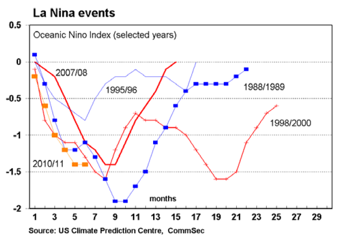
- The CPC says that the last El Niño event extended from May 2009 to May 2010. Effectively there have been rolling El Niño events from April 2002 through to 2010, with only a brief La Niña from August 2007 to Jun 2008. The last major La Niña was a two-year period from June 1998 to June 2000.
- In contrast to the dry noughties, the 1990s tended to be wetter than normal with a La Niña event occurring from 1995 to 1996 and then another event covering 1998 to 2000.
Implications of a La Niña weather event
- A raft of businesses and industries will be affected if a major La Niña event occurs across the summer months in Australia. Amongst those potentially affected are:
- Retailers of seasonal goods – clothing, electrical goods, outdoor equipment, swimming pool operators & equipment
- Utilities – reduced demand for power (air-conditioners, fans etc)
- Insurance companies – potential for floods, more traffic accidents
- Rural producers – effects will vary depending on where and when the rain falls, and in what quantities
- Builders/construction – potential for weather delays with more frequent rain days
What are the implications for investors?
- A strong persistent La Niña event would be pose risks for the economy in a general sense, but particularly for insurance, retail, construction and mining companies. For the Reserve Bank, it complicates decisions on interest rates. A key concern is that higher food prices may have more persistent effects in pushing up economy-wide inflation.
- Back in October we warned: “It is hard enough for investors to account for the vagaries of the economy, let alone the vagaries of the weather. And while La Niña events have predictable effects, climate models aren’t able to accurately determine whether a mild La Niña event is in prospect or something more severe. Still, for investors it is a case of forewarned is forearmed.” The risk with an extended La Niña is extended price weakness for retail and insurance stocks.
Produced by Commonwealth Research based on information available at the time of publishing. We believe that the information in this report is correct and any opinions, conclusions or recommendations are reasonably held or made as at the time of its compilation, but no warranty is made as to accuracy, reliability or completeness. To the extent permitted by law, neither Commonwealth Bank of Australia ABN 48 123 123 124 nor any of its subsidiaries accept liability to any person for loss or damage arising from the use of this report.
The report has been prepared without taking account of the objectives, financial situation or needs of any particular individual. For this reason, any individual should, before acting on the information in this report, consider the appropriateness of the information, having regard to the individual’s objectives, financial situation and needs and, if necessary, seek appropriate professional advice. In the case of certain securities Commonwealth Bank of Australia is or may be the only market maker.
This report is approved and distributed in Australia by Commonwealth Securities Limited ABN 60 067 254 399 a wholly owned but not guaranteed subsidiary of Commonwealth Bank of Australia. This report is approved and distributed in the UK by Commonwealth Bank of Australia incorporated in Australia with limited liability. Registered in England No. BR250 and regulated in the UK by the Financial Services Authority (FSA). This report does not purport to be a complete statement or summary. For the purpose of the FSA rules, this report and related services are not intended for private customers and are not available to them.
Commonwealth Bank of Australia and its subsidiaries have effected or may effect transactions for their own account in any investments or related investments referred to in this report.


